It’s New Year’s Eve in Kansas City, and we’re wrapping up 2024 with colder temperatures. Throughout the afternoon, the mercury will hover in the 30s before dipping into the upper 20s at midnight.
If you plan on celebrating outside, be prepared for wind chills in the upper teens. Although the northwest wind will ease up a bit, it will still blow consistently at 5-15 mph.
Later on, we can expect some breaks in the clouds, and the weather will remain dry throughout the region.
New Year’s Day is anticipated to have a drier and sunnier weather pattern, accompanied by light winds and daytime high temperatures ranging from 38° to 42°. This pleasant pattern will persist until Thursday, with slightly above-average temperatures.
However, a weak clipper system will approach from the northwest, posing a slight threat of wintry mix or light snow flurries on Thursday morning.
As temperatures rise above freezing, the precipitation will transition into cold rainfall. Although there may be a very light dusting, it should not significantly disrupt your daily routine.
As we near the end of the week and prepare for the upcoming storm system, a dip in the jetstream will contribute to a decrease in temperature.
We can expect a significant drop of nearly 10° from Thursday to Friday, with high temperatures reaching around freezing point.
Additionally, the wind will intensify, and clouds will form as a substantial low-pressure system approaches from the west.
Weekend Weather
The timing of the storm system entering the region is uncertain, with a possible range of mid afternoon Saturday to 12 o’clock in the afternoon Sunday.
Currently, there is a 50-50 chance of the area of low pressure dropping off the Rockies and transferring into the central Plains.
We are more confident in warning you about the initial entrance of the storm system on Saturday.
We are expecting a wintry mix or possibly freezing rain to occur during the late afternoon into the early evening on Saturday.
This will then transition into snowfall between 8 PM and 10 PM. The snow threat may continue throughout Sunday and finally taper off on Monday morning between 6 AM and 10 AM.
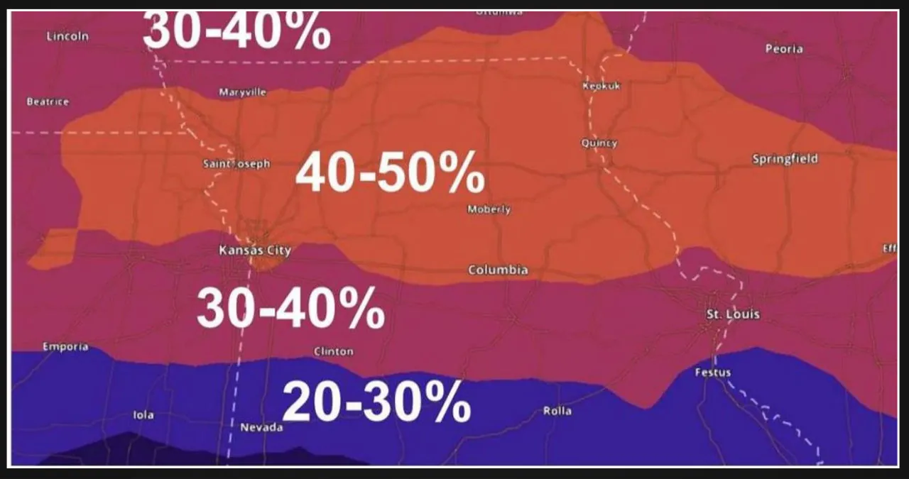
According to the latest modeling forecast, there have been some changes to the path of the low pressure system compared to the forecast 24 hours ago.
The new forecast shows that the system has shifted further south. As a result, we can expect more significant snowfall along I-70 and the metro area, extending all the way to St. Louis.
If this forecast holds true, the metro area could receive anywhere between 7 to 12 inches of snow, while our eastern counties along I-70 might see even higher amounts ranging from 13 to 20 inches.
On the other hand, our northern and southern counties can now expect snowfall totals ranging from 4 to 8 inches.
The timing of the low pressure system and its interaction with the jetstream from Canada, along with the high-pressure system in the Smokies and mid-Atlantic states, play a crucial role in determining the weather conditions.
Fortunately, there has been a significant change in the storm system over the past 24 hours, as it has shifted further south.
If this pattern continues in the coming days, we might be able to avoid heavy snowfall from the approaching low pressure area.
This storm system’s impact will greatly depend on its timing and speed as it moves through the Missouri River Valley.
Please note that the higher snowfall totals mentioned here are not definitive predictions for the weekend. As KCTV5, we want to provide you with the latest information and data that we have received, even though these values may change.
First warnings have been in effect since Saturday and will continue through Sunday and Monday morning. If the snowfall totals remain around 4 to 6 inches, we might consider issuing a first warning weather day, particularly for Sunday, as it appears to be the day with the highest probability of snowfall.
Next Week
As the winter storm system moves through, the area will experience much colder conditions. With Monday afternoon, temperatures will drop to a high of 19°, and the morning low temperatures will be in the single digits.